WeatherWhys: After a snowy December, why is January setting up to be dry and cold?
The Idaho Statesman and Idaho News 6 are trying something new.
Each week, the Statesman will chat with Idaho News 6 chief meteorologist Scott Dorval for a look at the Treasure Valley’s upcoming week in weather, anything interesting that happened in the past week, and even a weather lesson or two.
Following an extremely snowy December that saw Boise pick up 15 inches of snow — three times as much as normal and the snowiest December since 2008 — the area is set for a much calmer and drier January.
Put down your snow shovels … for now
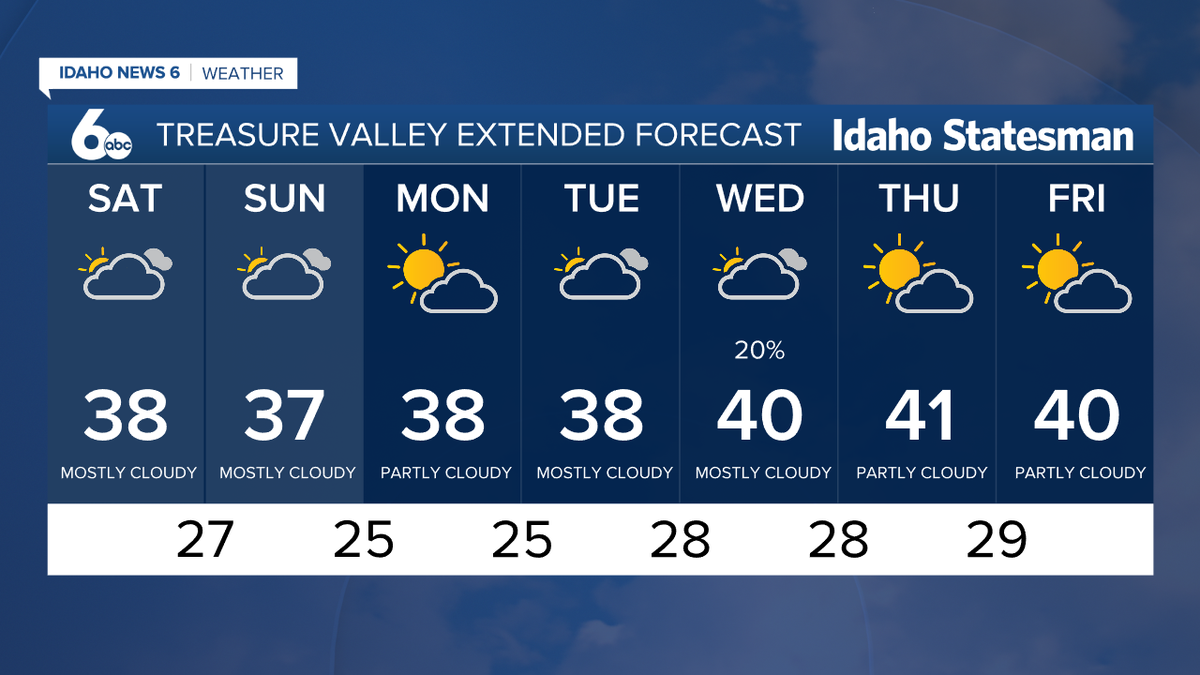
For those of you still struggling with back pain from the endless days of shoveling snow in December, you’re in luck heading into not only this week but the next couple of weeks.
The Treasure Valley is in for a quiet week, with the only chance for precipitation coming on Wednesday with a slim 20% chance of snow.
So why was December so snowy, and why is it suddenly so dry right now?
It comes down to La Nina, which is a weather pattern that sees cooler water upwelling along the Pacific Northwest coastline, strengthening the jet stream and causing storm after storm to form.
“Other places around the country tend to get dry during a La Nina weather pattern that we’re in,” Dorval said. “But for the Pacific Northwest, our forecast was for generally above normal precipitation, normal to above normal for most of the Northwest. And then a little bit cooler than average.”
A key facet to a La Nina weather pattern is the shift of the jet stream, which is a strong stream of air several miles above the Earth caused by the Earth’s rotation. The jet stream is influenced by the movement of warm and cold air, which in turn affects the amount of moisture and temperatures that an area sees.
As the dip in the jet stream has moved further east, Dorval is expecting heavy storms to hit the Southeast United States before a heavy snowstorm plows through the Northeast. By the end of the month, the jet stream will have shifted again to bring strong storms back to the Northwest.
In essence, there is always a location somewhere in the United States that is experiencing stormy weather.
“The weather pattern oftentimes will go four to six weeks, and then it will flip flop,” Dorval said. “And so we have these surges of moisture, and then it stops, and then it returns later.”
Dorval expects the weather pattern to flip back around Jan. 27 as the stream takes a dramatic dip down the West Coast, allowing a storm to track down from the north, picking up moisture from the Pacific Ocean before swinging east toward Idaho.
Inversion and air quality: How are they connected?
You’ve probably heard of inversions before. It’s tough to live in the Treasure Valley without hearing about them.
But what exactly is an inversion, what does it do and why does it happen? Without throwing too much weather information at you for one week, this is Dorval’s brief explanation:
“Inversion means inverting the normal temperature profile. … We get warm air over the top of the cold air, that’s an inversion, and that traps anything that’s produced; moisture or pollution gets trapped below that warm layer.”
With the Treasure Valley being just that, a valley, cold air is susceptible to sinking down into the valley and being trapped by warm air above — think about water and oil separating from one another in a jar.
When the cold air gets trapped in the valley, days of not only cooler temperatures can occur but air quality can be affected as pollutants get trapped under the warm air above the valley.
That has led the Idaho Department of Environmental Quality to issue a yellow/moderate warning for air quality on Thursday and Friday. Those conditions can be expected to continue into the week and onward as a dry spell sets itself up over the Valley.
This story was originally published January 14, 2022 at 4:00 AM.